Sinking Land Causes California Water Chokepoint
Buckled canals, damaged because of groundwater pumping, impair state’s ability to deliver water and control floods.

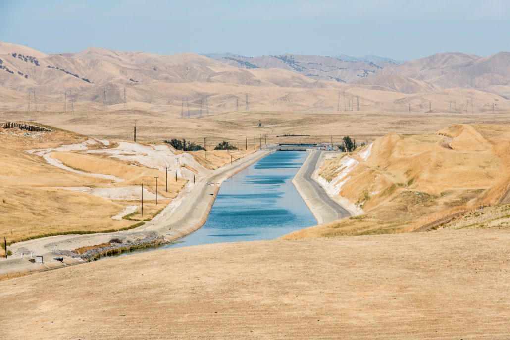
The California aqueduct in Stanislaus County. Farms pumped so much groundwater during the state’s recent drought that land around parts of the aqueduct sank, causing the canal to buckle. Photo courtesy of Florence Low / California Department of Water Resources
By Brett Walton, Circle of Blue
Unchecked groundwater use is colliding with seesawing weather patterns to produce a new act in California’s long-running tragedy of the commons.
According to NASA and European Space Agency data released on February 8, parts of the California aqueduct on the west side of the San Joaquin Valley, near Avenal, sank more than two feet between 2013 and 2016 as farmers pumped records amounts of groundwater during the state’s historic drought.
The aqueduct is the 444-mile-long main artery in the state’s north-south water canal system, which was built in the 1960s. The system delivers water from reservoirs in the Sierra Nevada mountain range to 25 million urban residents and nearly one million acres of irrigated farmland in southern California.
The two-foot dip “creates a chokepoint” in the aqueduct, says Jeanine Jones, interstate resources manager at the California Department of Water Resources. Department models show that the canal today can move 15 to 20 percent less water than its designed capacity. This means that cities and farms in the southern half of the state might not be able to take full advantage of big storms this winter even though state officials have increased water delivery forecasts. Congress also passed a measure last December to maximize water pumping from the Sacramento-San Joaquin delta to fill canals.
The entire scenario is filled with irony. The California aqueduct transports water to the Central Valley and Southern California cities in order to reduce groundwater pumping that was causing a land subsidence crisis in the mid-20th century. Today, the canals themselves are at risk from the same forces.
William Croyle, director of the California Department of Water Resources, called the land subsidence documented in the report “troubling and unsustainable.”
“Subsidence has long plagued certain regions of California,” Croyle said in a statement. “But the current rates jeopardize infrastructure serving millions of people. Groundwater pumping now puts at risk the very system that brings water to the San Joaquin Valley. The situation is untenable.”
Just months past one of the driest four-year periods in state history California is now awash in fresh water. The drought ended in dramatic fashion in the last two months in a relentless series of Pacific storms. The Sierra snowpack is the largest in more than two decades, nearly 80 percent above normal, while the northern Sierra Nevada is on track for its wettest year on record. Reservoirs are above average and many are nearing full capacity. So much water poured this week through Oroville Dam, the tallest dam in the United States and the primary reservoir for the State Water Project, that it ripped a hole in the dam’s concrete spillway. The state is now actually running out of places to store extra water.
California cities and farms are expecting to receive a big water dividend from the wet winter. The shrinking of land near major canals, however, complicates an otherwise rosy water outlook. Subsidence, as the sinking is called, skews the canal’s precision engineering, which is designed to slope downward at one-half-foot per mile. Subsidence is causing water to pool in the 27-inch dip near Avenal where the land has collapsed. The area around the aqueduct affected by subsidence of more than eight to 10 inches has grown roughly four-fold since NASA’s previous report, in August 2015.
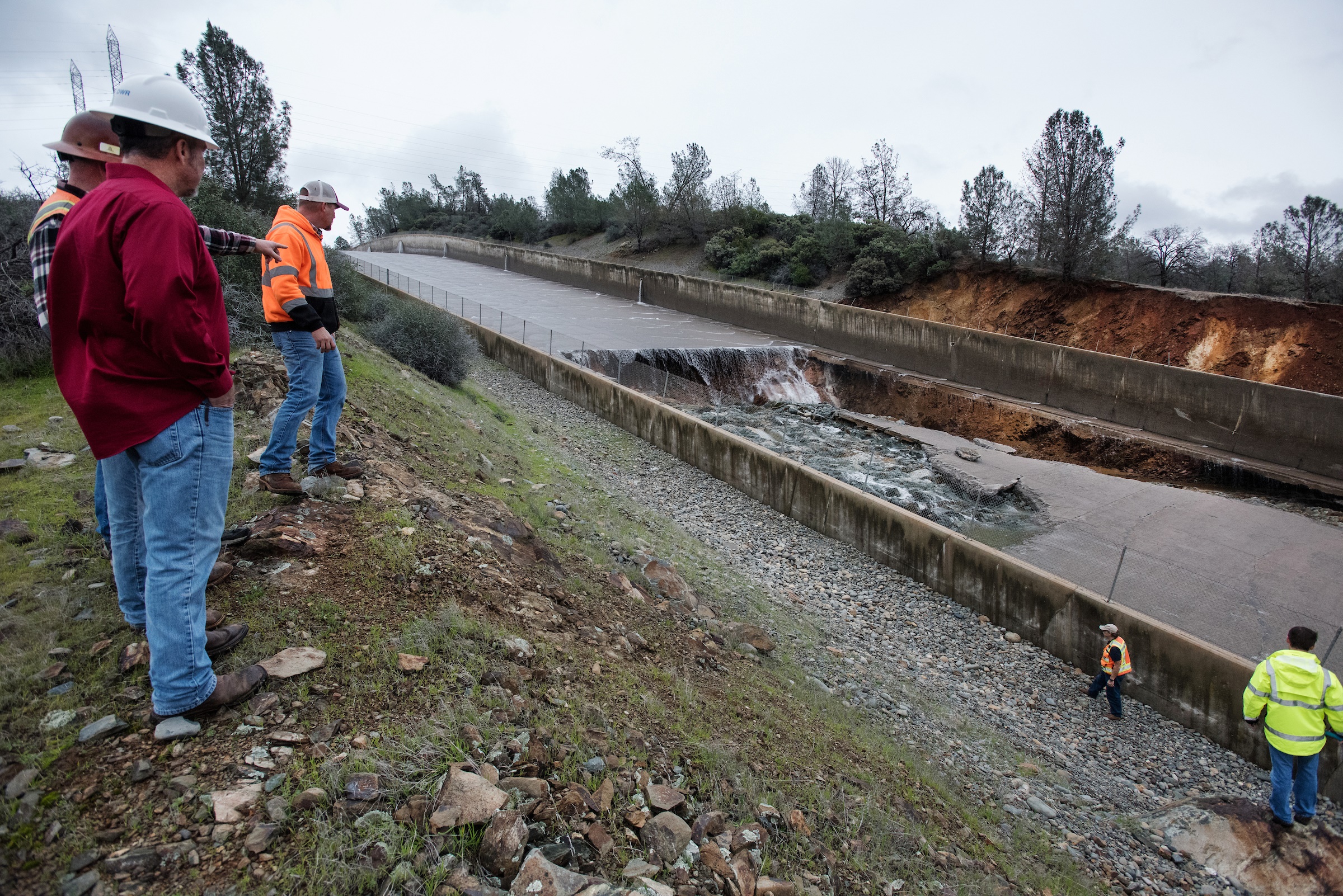
Workers view the hole that opened this week in the concrete spillway at Oroville Dam, which supplies water to state canals. Department of Water Resources engineers are assessing options to repair the spillway and control the reservoir water level. Photo courtesy of Kelly M. Grow / California Department of WaterResources.
Though subsidence developed over years, this is the first winter in a decade that there is enough water to fill canals. Officials will see if department models of carrying capacity reflect the aqueduct’s real-time performance. “We essentially have a test of the system this year,” Jones told Circle of Blue.
The Avenal zone is one of three subsidence hot spots that NASA and state agencies have been tracking in recent years. The hotspots are adjacent to key pieces of California’s water delivery and flood control infrastructure: the California aqueduct, the Delta-Mendota canal, and the Eastside bypass.
NASA found subsidence of up to 22 inches along the Delta-Mendota Canal, part of the federal Bureau of Reclamation’s Central Valley Project water supply system. A bowl of subsidence roughly 25 miles in diameter and 16 inches to 20 inches in depth extends across the Eastside bypass, a flood control structure used to shunt water away from the San Joaquin River during spring floods in years with deep snowpack. Subsidence has caused the bypass’s levees to shrink by five to six feet, Jones said. Dips in the land surface in the bypass could cause water to back up into areas that are not protected by levees, Jones said. That would flood homes.
Subsidence is intimately connected to groundwater pumping, says Cathleen Jones, a NASA Jet Propulsion Lab scientist who wrote the report. “It’s not linear. We see a really rapid rate of decline in the summer. Then it levels off when groundwater pumping levels off,” she told Circle of Blue.
Subsidence does more than harm infrastructure. It also reduces the land’s capacity to hold water. Sand and gravel lies beneath the San Joaquin Valley, along with layers of clay. When these soils compact, the pores between soils collapse, resulting in a loss of water storage and a settling of the land.
The Department of Water Resources is considering options for addressing subsidence. Emergency repairs such as raising the lining of the canals near the hotspots would cost “tens of millions of dollars,” according to Jones.
They are also looking at legal tools. Department officials are combing through well drillers’ reports to document the number, location, and depth of wells within one mile of the aqueduct. So far they have found thousands, Jones said.
Pumping restrictions on these wells or a prohibition on new drilling are possible avenues of action, but such an “infrastructure protection zone” around canals would “require new legal authority,” Jones asserted.
The Sustainable Groundwater Management Act, a landmark state law passed in 2014 that requires local agencies to rein in groundwater use, will presumably address the problem in the long-run, Jones noted. But the act’s timetable — agencies are not required to establish sustainable use until 2040 — is too slow to help now.
Brett writes about agriculture, energy, infrastructure, and the politics and economics of water in the United States. He also writes the Federal Water Tap, Circle of Blue’s weekly digest of U.S. government water news. He is the winner of two Society of Environmental Journalists reporting awards, one of the top honors in American environmental journalism: first place for explanatory reporting for a series on septic system pollution in the United States(2016) and third place for beat reporting in a small market (2014). He received the Sierra Club’s Distinguished Service Award in 2018. Brett lives in Seattle, where he hikes the mountains and bakes pies. Contact Brett Walton