Landslide Lake Puts Pakistani Villages at Risk of Flooding
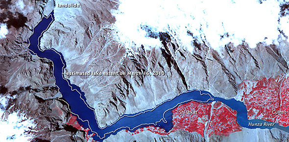
A lake that formed from a January landslide has left several villages inundated upstream because of rising water levels. With seasonal rains slated to begin next month, officials are working quickly to protect the 20,000 people who face potential displacement.
UPDATE FROM JUNE 7, 2010: A tidal wave, reaching up to 60 meters high, is expected to race through the Hunza valley of the Himalayas—displacing an additional 25,000 people—unless the Pakistan army can divert significant volumes of water flow.

A lake formed by a January landslide in northern Pakistan has continued to grow, putting the lives of thousands of villagers at risk if the water body breaches its rock dam, the BBC reports.
Pakistani officials said the danger will be greatest when seasonal rains begin next month, according to the BBC. If the dam is breached, as many as 20,000 people in 36 villages could be displaced downstream.
Four months ago, debris from a rock slide clogged the River Hunza, forming what is now called the Attabad lake. The rising waters, now 100 meters deep in the 15-kilometer reservoir, have already displaced more than 3,000 people upstream in the Hunza Valley.
A two-kilometer stretch of the Karakoram Highway connecting Pakistan with China is blocked from the rock slide, halting trade between the two countries, Pakistan’s Express Tribune reports. Flood waters could wash away large sections of the road.
Engineers from India’s National Disaster Management Authority are constructing a spillway to drain the lake, but the BBC’s correspondent said progress has been slowed due to indifference. Although officials said in February they would begin releasing water by mid-March, the spillway still has not been completed.
AFP reports that army engineers are now saying the spillway will be ready in two weeks.
Landslide dams are a recurrent hazard in the mountains of southern and central Asia. Steep valleys, high seismic activity and periods of heavy precipitation contribute to the risk. A rock fall in northern India in 1993 completely stopped the flow of the Sutlej, a main tributary of the Indus, for 30 minutes and partially submerged a dam upstream, halting electrical generation for months.
Source: BBC, Express Tribune, AFP

Brett writes about agriculture, energy, infrastructure, and the politics and economics of water in the United States. He also writes the Federal Water Tap, Circle of Blue’s weekly digest of U.S. government water news. He is the winner of two Society of Environmental Journalists reporting awards, one of the top honors in American environmental journalism: first place for explanatory reporting for a series on septic system pollution in the United States(2016) and third place for beat reporting in a small market (2014). He received the Sierra Club’s Distinguished Service Award in 2018. Brett lives in Seattle, where he hikes the mountains and bakes pies. Contact Brett Walton


Leave a Reply
Want to join the discussion?Feel free to contribute!