Ongoing Texas Drought Threatens Supply from Two Reservoirs on Colorado River
With the amount of reliable water in reservoirs shrinking, water agencies set sights on groundwater transfers and more reservoirs.

By Brett Walton
Circle of Blue
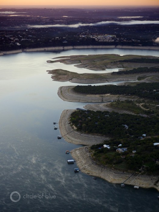
Two big reservoirs on the Colorado River in Texas are approaching a red line that would, in the short term, trigger mandatory water restrictions for the cities, golf courses, and companies that hold a contract with the Lower Colorado River Authority, the regional water manager. But in the long term, if the three-year drought in Texas continues, water rights in LCRA’s service area may need to be recalculated and reduced dramatically, potentially accelerating an ongoing search for reliable water supplies throughout central Texas.
After a dry summer, the day of reckoning appeared imminent for the 965-kilometer (600-mile) stretch of the Colorado River in Texas that is managed by LCRA, but periods of heavy rain in September and October delayed the squeeze, at least for now. Climate forecasts show no sign that the region will soon break out of the low-moisture cycle that has cinched tight the flow of water into the river authority’s keystone reservoirs.
The two reservoirs are now 35 percent full, the recent rains having increased storage by 4 percentage points since early September. But at the current rate of depletion, the reservoirs could fall below the drought-of-record threshold by early next year. Passing that mark would result in a temporary 20 percent cut in water allocations for all 136 contract holders, who would then implement the cuts according to their individual drought-management plans.
If the combined storage in Lake Travis and Lake Buchanan — part of the Highland Lakes reservoir system, upstream from Austin — falls below 30 percent capacity, or 740 million cubic meters (600,000 acre-feet), the LCRA board will declare a new drought of record for its service area, an action that will lead to systematic changes for water supplies in one of the state’s largest watersheds.

Cities Look Elsewhere
In the long term, a new drought of record would have a domino effect on water supplies throughout the Colorado River Basin. Such a declaration would mean that the firm yield from LCRA’s reservoirs — the water rights that are guaranteed to contract holders — would be recalculated and reduced. On paper, cities would suddenly have fewer water rights than they used to.
–Michael Booth, water attorney
Booth, Ahrens, & Werkenthin in Austin, TX
Preparation for this possible scenario is already underway in fast-growing central Texas — where Austin alone currently has 840,000 residents and is adding roughly 17,000 people per year — with cities looking elsewhere for supplies. But acquiring them could lead to conflicts with the rural water districts that would be targeted for transfers.
LCRA, which supplies drinking water to more than 1 million people, has two immediate plans: build a new reservoir downstream to capture water during wet years and drill new wells in a nearby rural groundwater district. Austin, which gets all of its supply from the Colorado River reservoirs, is opening its own search. In August, the city council agreed to pay Alan Plummer Associates, a Texas-based consultant, between $US 200,000 and $US 892,445 for a drought-management plan. The plan will consider options to decrease demand, as well as increase supply.
The Texas capital, which would see a cut in firm yield if Lake Travis and Lake Buchanan keep dropping, is not alone in the hunt for water, according to Michael Booth, a lawyer with Booth, Ahrens, & Werkenthin, an Austin-based firm that specializes in water law. Other cities in the region are also looking, even as conservation plans are currently keeping municipal demands stable.
“Even when it’s raining, cities are looking at growth,” Booth told Circle of Blue. “Firm yield is always out there. Each reservoir owner will determine the drought of record and eventually incorporate that into their planning. If yield drops, cities will want to get even more supply.”
Meanwhile, the state legislature endorsed a plan with bipartisan support earlier this year to create a $US 2 billion water fund from money in state reserves. Cities could apply for low-interest loans to fund water-supply and water-conservation projects. The measure, called Proposition 6, is on the November 5 ballot and is expected to pass.
New Supplies
In January, the LCRA board approved two new supply projects. The larger is an old-fashioned scheme: a reservoir on the Colorado River in Wharton County, 80 kilometers (50 miles) from the Gulf of Mexico. The reservoir will provide an estimated 111 million cubic meters (90,000 acre-feet) of firm yield. The board set aside $US 18 million for the first phase of construction, and the project should be completed by 2017.
The other project looks underground, to an aquifer east of Austin that recently reopened for development after a three-year moratorium. LCRA will spend $US 15 million on wells in Bastrop County, where the Lost Pines Groundwater Conservation District manages the supply.
This year, Lost Pines approved withdrawal permits totaling up to 33.3 million cubic meters (27,000 acre-feet), said Jim Totten, the district’s assistant general manager. The largest permit went to Forestar Real Estate Group, a water marketer. Other permits were granted to LCRA, the town of Bastrop, and Heart of Texas, a water supplier.
Earlier this month, Forestar inked a $US 1 million deal to sell its allocation to Hays County, south of Austin. Yet Forestar wants still more water from Lost Pines — nearly four times the amount that the groundwater district permitted the group to take — and Forestar could file a lawsuit to get it, the Austin American-Statesman reports.
With the weather as it is, Totten expects even more applications for water from his district.
“I’d be surprised if there weren’t,” Totten told Circle of Blue. “With the drought, when reservoirs drop, the only other option people turn to is groundwater.”
Indeed, groundwater has been a savior across the Western United States in recent dry years. Farmers in New Mexico weathered record-low rainfall in 2012 by pumping more water from aquifers. The city of Amarillo in the Texas Panhandle is using groundwater exclusively for drinking water now that Lake Meredith, its main reservoir, has dried up.

Setting a Precedent or Precedent-setting?
There is precedent in Texas for recalculating a drought of record. The Brazos River Authority, whose domain stretches from the Panhandle to the Gulf of Mexico, did it around 2001 for Lake Proctor, one of 11 reservoirs that the authority operates. Contracts for water from the lake had to be renegotiated after the authority determined that firm yield was 30 percent lower than before, said Brad Brunett, water services manager for Brazos River Authority.
Under either wet or normal conditions, rights holders received their full allotment. Only under drought conditions did the reduced rights come into play.
–Jim Totten, assistant general manager
Lost Pines Groundwater Conservation District
“We self-police within the bounds of our water rights,” Brunett told Circle of Blue. “We don’t want to promise water to contract holders that won’t be there.”
Will it be there? That is the question LCRA now faces. If combined storage drops below 30 percent the answer is a clear “No” — at least, not in the expected amounts. How much is available? Another question that needs answering.
LCRA told Circle of Blue that breaching the 30-percent storage threshold in the Highland Lakes means a new record is declared. A determination about how it will affect firm yield will come later, when the drought is over and complete hydrological data are compiled. But some cuts have already taken place: LCRA denied water to farmers downstream of the Highland Lakes reservoirs each of the last two years, for the first time ever, and Austin residents are only allowed to water their lawns once per week.
Brett writes about agriculture, energy, infrastructure, and the politics and economics of water in the United States. He also writes the Federal Water Tap, Circle of Blue’s weekly digest of U.S. government water news. He is the winner of two Society of Environmental Journalists reporting awards, one of the top honors in American environmental journalism: first place for explanatory reporting for a series on septic system pollution in the United States(2016) and third place for beat reporting in a small market (2014). He received the Sierra Club’s Distinguished Service Award in 2018. Brett lives in Seattle, where he hikes the mountains and bakes pies. Contact Brett Walton


Leave a Reply
Want to join the discussion?Feel free to contribute!