
Two NASA Satellite Missions Fill Gaps in Water Knowledge: 2014 Preview, Part II
From soil to stratosphere, scientific understanding of the water cycle will take a giant leap in 2014.

By Brett Walton
Circle of Blue
Neither obstructed by political borders nor thwarted by daunting terrain, satellites gather data that are otherwise inaccessible. Hundreds of kilometers aloft, high-tech instruments reveal the big-stage physical changes that are shaping and reshaping the planet.
–Gail Skofronick-Jackson, project scientist
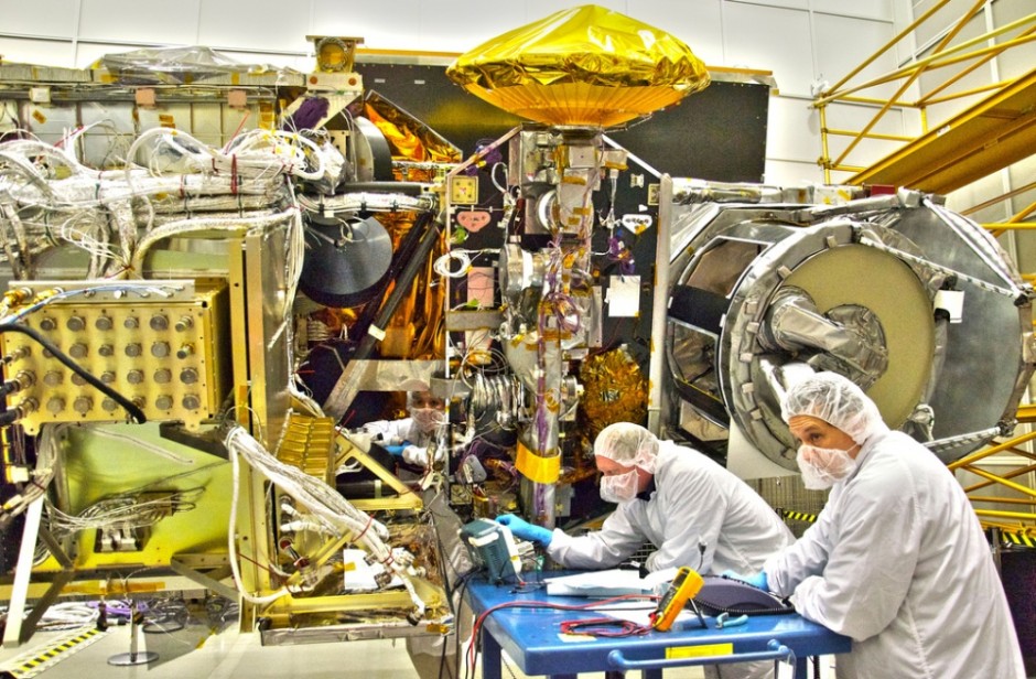
NASA’s GPM Mission
Two such satellites will be placed into orbit in 2014, with significant implications for hydrology, climate science, drought prediction, and flood forecasting. Some of the data will even clarify hazy aspects of the carbon cycle.
Launching February 27 from Tanegashima Space Center in Japan, the Global Precipitation Measurement (GPM) satellite will provide the most comprehensive picture to date of snowfall and rainfall across most of the Earth’s oceans and land mass. GPM is a partnership between the Japanese Aerospace Exploration Agency and NASA.
On board are two types of sensors. They will transmit both two-dimensional and three-dimensional images of the internal structure of clouds. They will also be able to determine whether the clouds are spitting out rain or snow. This information – from the first NASA satellite to detect falling snow – will help scientists understand how storms evolve, said Gail Skofronick-Jackson, the mission’s deputy project scientist.
“The ultimate goal is to map global precipitation, see how it changes over time, and improve climate forecasting,” Skofronick-Jackson told Circle of Blue.
Nine months later, a related mission will observe what happens to the precipitation once it hits the ground. Scheduled for a November 5 launch from Vandenberg Air Force Base in California, NASA’s Soil Moisture Active Passive (SMAP) mission will measure the amount of moisture in the ground and whether it is liquid water or ice.
— Dennis Lettenmaier, hydrologist
University of Washington
The amount of moisture is important for predicting droughts and floods. A shift between ice and liquid water indicates the beginning or end of the growing season in colder climates, a key transition point in the carbon cycle. Called the ‘freeze-thaw’ state, this transition is understood today only by correlation with air temperatures, a poor substitute.
Together, data from the two missions will shed light on how water moves between the Earth and the atmosphere. If both missions proceed without a hitch, “it will be a big year for hydrology,” Dennis Lettenmaier, a hydrology expert at the University of Washington, told Circle of Blue.
Better Instruments, Better Data
Existing satellites already measure precipitation and soil moisture, but their range is limited and their instruments are rather rudimentary. The two missions that are launching in 2014 will broaden the frame, sharpen the image, and transmit the data more often.
SMAP will map soil moisture across the planet every three days, while GPM will make the same sweep for global precipitation in just three hours. GPM’s response time is much quicker than SMAP because it is acting as a conductor, using its superior instruments to refine and integrate data from a group of partner satellites, thus expanding its reach.
“We’ve never had the ability to monitor global change so frequently,” Eni Njoku told Circle of Blue. Njoku is a SMAP project scientist who uses the satellite data to study the water cycle.
Eyes in the Sky and on the Ground
The view from above will complement measurements taken on the ground, particularly for soil moisture which is an essential variable for anticipating droughts and floods. When the ground is saturated, for instance, a rainstorm is more likely to cause rivers to top their banks. To forecast such calamities, however, scientists need a wide-angle view.
–Eni Njoku
NASA research scientist
Monitoring stations for soil moisture are relatively sparse and provincial, but scientists have begun stitching together these disparate nodes into a more unified network. In December, Texas A&M University unveiled the first North American soil moisture database, with data from at least 1,300 stations that are operated by governments and universities in Canada, Mexico, and the United States.
The point measurements from the in-ground sensors are important for checking the validity of the satellite data, but they cannot describe the regional or continental trends that are required for flood and climate prediction, Njoku explained. That is why GPM and SMAP are so important.
Both missions are scheduled to last three years, but they will likely send data for far longer. Skofronick-Jackson said that the GPM satellite has enough extra fuel to orbit for five more years.

Brett writes about agriculture, energy, infrastructure, and the politics and economics of water in the United States. He also writes the Federal Water Tap, Circle of Blue’s weekly digest of U.S. government water news. He is the winner of two Society of Environmental Journalists reporting awards, one of the top honors in American environmental journalism: first place for explanatory reporting for a series on septic system pollution in the United States(2016) and third place for beat reporting in a small market (2014). He received the Sierra Club’s Distinguished Service Award in 2018. Brett lives in Seattle, where he hikes the mountains and bakes pies. Contact Brett Walton


Leave a Reply
Want to join the discussion?Feel free to contribute!