Study: Line 5 Oil Spill Would Inundate Large Swaths Of Great Lakes Shoreline
Researchers identify areas where oil could spread in Lake Huron and Lake Michigan.
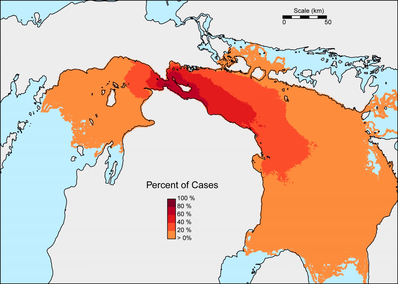
Researchers ran 840 simulations of an oil spill from the pipelines crossing the Straits of Mackinac. This map shows the probability of where oil would be found in the open waters of Lake Michigan and Lake Huron. Map courtesy University of Michigan Water Center
By Codi Kozacek, Circle of Blue
More than 1,000 kilometers (621 miles) of shoreline and 44,000 square kilometers (17,000 square miles) of open water in Lake Huron and Lake Michigan could be at risk if oil spilled from twin 63-year-old underwater pipelines that run below the Straits of Mackinac, according to a study released Thursday by the University of Michigan Water Center and supported by the National Wildlife Federation’s Great Lakes Regional Center.
It is the latest analysis of the threat posed by Enbridge, Inc.’s Line 5, which carries oil and natural gas products from Canada through the straits pipelines to refineries in southern Michigan and Ontario. The line has been the focus of intense public scrutiny since a 2012 report by the National Wildlife Federation highlighted concerns about the integrity of the aging pipelines, as well as the operating record of Enbridge, the company responsible for a 2010 oil spill into Michigan’s Kalamazoo River. That incident was the worst inland oil spill in U.S. history.
Subsequent reports and studies found that the straits, a turbulent 10-kilometer (6.2-mile) stretch of water connecting Lake Huron and Lake Michigan, would be the worst possible place for an oil spill in the Great Lakes because it could quickly spread along shorelines in both lakes, affecting Michigan and Ontario.
A Michigan state task force last summer issued a harsh critique of the Line 5 crossing, noting that available information was “insufficient to independently verify Enbridge’s public assurances regarding the ‘excellent condition’ of the Straits Pipelines or that its existing practices ensure that ‘the likelihood of a leak in the Straits is low.’”
In December, an independent analysis commissioned by For Love of Water (FLOW), a Traverse City-based water law and policy group, further asserted that the oil products carried by Line 5 below the Straits of Mackinac can be delivered to customers utilizing other existing pipelines that do not cut through the Great Lakes, rendering the straits pipelines unnecessary.
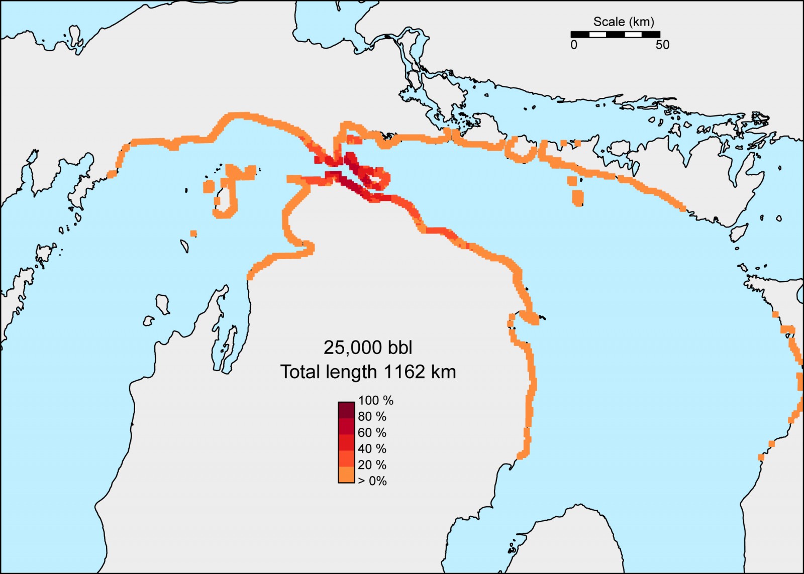
In the worst case scenario of a 25,000-barrel oil spill in the Straits –the same amount that spilled near the Kalamazoo River in 2010–up to 245 kilometers of shoreline could be affected. This map shows the probability that beached oil concentrations would exceed the threshold needed to trigger shoreline cleanup. Map courtesy University of Michigan Water Center
The new study simulated 840 oil spill scenarios from the Line 5 pipelines, analyzing spill amounts of 5,000, 10,000, and 25,000 barrels of oil. Enbridge has estimated that a worst-case oil spill could release 8,583 barrels of oil from the straits pipelines. The 2010 pipeline rupture near Kalamazoo released approximately 25,000 barrels of oil.
The study found that a single spill of 10,000 barrels would most likely contaminate 85 kilometers (53 miles) of shoreline and 300 square kilometers (116 square miles) of open water, assuming that no action is taken to contain or recover the oil. Mackinac Island, Bois Blanc Island, and Round Island were noted as the areas that would be most affected, with significant amounts of oil reaching their shorelines in more than 80 percent of the simulations.
However, depending on when and where a spill occurs within the straits, oil could potentially flow along a variety of different paths. In some simulations, it reached as far south as Saginaw Bay in Lake Huron and the tip of Leelanau County in Lake Michigan. In total, the amount of open water in the Great Lakes vulnerable to a spill covers an area larger than Massachusetts and Connecticut combined, while the length of shoreline at risk is equivalent to the distance between Detroit and Atlanta.
The study used a model based on water and weather conditions between April and December. It did not assess how a spill might behave under ice conditions.
“Until now, no one knew exactly how much shoreline was vulnerable to spills in the Straits of Mackinac,” said David Schwab, a research scientist at the U-M Water Center, in a press release. “These findings show that under the right conditions, a spill in the Straits of Mackinac could affect a significant amount of shoreline and open-water areas in either Lake Michigan or Lake Huron, or both, very quickly.
“We hope this information will inform spill-response planning and will help government officials make sound decisions about the oil pipeline beneath the straits.”
Michigan’s Pipeline Safety Advisory Board, created in September 2015 in response to the state task force report about Line 5, is currently conducting independent analyses of the risks and alternatives to the straits pipelines.
A news correspondent for Circle of Blue based out of Hawaii. She writes The Stream, Circle of Blue’s daily digest of international water news trends. Her interests include food security, ecology and the Great Lakes.
Contact Codi Kozacek






Leave a Reply
Want to join the discussion?Feel free to contribute!