This Is What Extreme Drought Looks Like, On a Graph
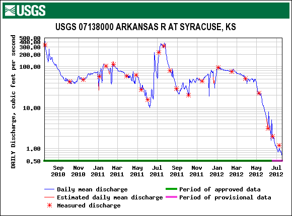
The Arkansas River in western Kansas is flowing at less than 1 percent of normal.

The Arkansas River barely deserves the name right now. As this graph from the U.S. Geological Survey shows, the river has almost bottomed out at the Syracuse, Kansas gauging station, near the Colorado border. The flow there is just 0.63 cubic feet per second–less than 1 percent of the historical average for this time of year.
Yesterday, NPR ran a story about how the lack of water hurts multiple sectors in the Arkansas River Basin: rafting companies, farmers, and cities.
How is the drought affecting you? Contact Brett Walton
Brett Walton
Circle of Blue reporter
Brett writes about agriculture, energy, infrastructure, and the politics and economics of water in the United States. He also writes the Federal Water Tap, Circle of Blue’s weekly digest of U.S. government water news. He is the winner of two Society of Environmental Journalists reporting awards, one of the top honors in American environmental journalism: first place for explanatory reporting for a series on septic system pollution in the United States(2016) and third place for beat reporting in a small market (2014). He received the Sierra Club’s Distinguished Service Award in 2018. Brett lives in Seattle, where he hikes the mountains and bakes pies. Contact Brett Walton


Leave a Reply
Want to join the discussion?Feel free to contribute!