Virginia Officials Recognize Groundwater Pumping Allows Sea To Rush In
Reversing aquifer decline will test state oversight and local response.

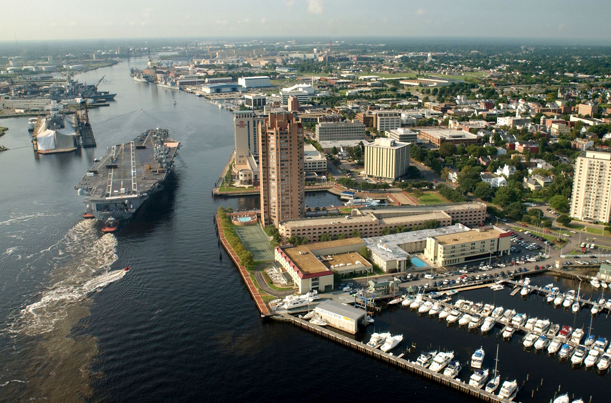
The Elizabeth River passes by Portsmouth, Virginia, before draining into the Chesapeake Bay. Portsmouth has one of the highest rates of sea level rise on the East Coast. Photo via Wikimedia Commons
By Brett Walton, Circle of Blue
The Tidewater region of eastern Virginia, swayed daily by the ebb and flow of the Chesapeake Bay, is a wet region with a serious water problem. Due to heavy pumping, water levels in the Potomac aquifer, the area’s principal groundwater source, have dropped by 100 to 200 feet in the last century. The consequences of removing so much water are profound. The land, like a sponge wrung dry, is sinking and the waters at the south end of the bay are rising at the fastest rate of any site on the U.S. Atlantic Coast.
The region’s collection of economic, urban, and military assets raises the stakes of inaction. Tidewater is home to one of the largest ports on the East Coast, four of the five largest cities in the state, and the world’s largest naval base, Naval Station Norfolk. The city of Norfolk, the state’s second most populous urban area, has seen the number of high-tide floods increase more than four-fold since the 1960s. Rising seas are one factor in the flooding, but sinking land due to groundwater withdrawals worsens the inundation.
Recognizing the problem is the first step to recovery, and Virginia officials have done that. Like farmers in northwest Kansas, seaside water agencies in California, states in the lower Colorado River Basin, and others across the United States, they are responding to a manmade threat by changing the business-as-usual attitude that created it. The shift is slow in some cases but the reshuffling of priorities is evident.
One of the first big moves in Virginia happened four years ago, when state regulators began cutting groundwater withdrawal permits for industrial and municipal customers and prohibited new permits in most of the region. Then last year, lawmakers convened an advisory panel with representatives from industry, agriculture, utilities, universities, and federal agencies to recommend new management actions for the long-term sustainability of the aquifer. Today, the region’s largest wastewater utility is testing a $US 1 billion system that, if approved, will inject purified wastewater into the aquifer to slow or halt its decline, prevent further compaction of clay soil layers, and stabilize the land surface.
“Planners, managers, and scientists realize that where you have two millimeters per year of sea level rise, another one to three millimeters per year from compaction is pretty substantial,” Jason Pope, a U.S. Geological Survey hydrologist based in Virginia, told Circle of Blue.
Even lawmakers see the need to act. A legislative commission report published this month and written by fourteen members of the Virginia House of Delegates and Senate acknowledged recent progress on reducing permitted withdrawals. But the report also noted significant inadequacies in the state’s legal authority, water supply planning process, and knowledge base.
“Sustainability is tenuous, and can easily be tipped out of balance,” the Joint Legislative Audit and Review Commission (JLARC) concluded.
Steps to Stabilizing the Land
Tidewater is an appropriate name. The James, Rappahannock, Potomac, and York rivers divide the state’s bayside lowlands into peninsular “necks” that thrust into the Chesapeake, where salt water mixes with fresh. The daily push and pull of the bay’s waters — charging through salt marshes, pocosin wetlands, and swamps, then out again — gives the region its liminal moniker.
Groundwater use has been relatively constant since 1986. But because groundwater moves slowly the effects of the recent pumping — on river flows, land subsidence and the inland penetration of saltwater — still are not fully known. John Masterson, a U.S. Geological Survey hydrologist who studies the Potomac aquifer told Circle of Blue that, because of the slow underground movement of water, at current rates of use the aquifer will continue to decline. “The system is going to take decades to reach equilibrium,” he said.
Where groundwater levels have dropped most is near Franklin, about 40 miles southwest of Norfolk. A paper mill there was the largest groundwater user in the region and caused water-level declines that extended into North Carolina. Closed in 2010, the mill has reopened.
The reliance on groundwater has far-reaching consequences. The most notable is the sinking of the land. According to the U.S. Geological Survey, half of the observed sea level rise in Tidewater is due to land subsidence, which is why the region is a hotspot for tidal flooding. Most of the subsidence is due to groundwater pumping, and the rest is related to a reshaping of the earth’s crust because of glacial melt.
One solution to subsidence is to cut withdrawals. The Virginia Department of Environmental Quality is negotiating new permits for 14 of the largest consumers. Five new permits have been completed so far, and the state cut permitted withdrawals by 62 percent. Users were not necessarily withdrawing the entire permitted amount, but it is a necessary first step, according to Scott Kudlas, director of the Department of Environmental Quality’s Office of Water Supply. One permit under negotiation would have the James City Service Authority reduce actual withdrawals by 30 percent. The utility plans a $US 128 million surface water project as a replacement.
The inability for the state to authorize new withdrawals is a roadblock for industries wanting to relocate to the region. The JLARC report notes that three potential developments in the last three years did not materialize because of uncertainty about acquiring a permit.
Another remedy: put water back into the ground. That is the goal of the Hampton Roads Sanitation District, which serves 1.7 million people in the Tidewater region and is routinely lauded for its progressive thinking. Its leadership is championing a $US 1 billion project that will, at full buildout, purify 120 million gallons of wastewater per day and inject it into the Potomac aquifer. It is similar in concept to an award-winning water recycling facility in Orange County, California.
“Cutting subsidence is a huge positive for southeastern Virginia,” Ted Henifin, the district general manager, told Circle of Blue.
The project has other benefits too. It will reduce nutrient discharges into the Chesapeake Bay, which contribute to toxic algal blooms and harm the bay ecosystem.
The district is in the trial phase. It drilled two test wells to gauge the capacity of the aquifer to absorb the injected water. Last month, state officials approved the quality of water produced from a pilot site at the York treatment plant. Next year, the district will build a one-million-gallon-per-day test facility at its Nansemond plant. If that goes well and all state and federal permits are acquired, Henifin hopes to have treatment and injection facilities at seven of the district’s facilities by 2030.
Lack of Data
Despite its prominent role in Virginia’s public policy, land subsidence data is scarce. The rise and fall of the land surface is directly measured in only two locations in Tidewater — neither near the coast — and no data has been collected since 1995, when funding for the extensometers ran out.
“There was no interest in subsidence because it hadn’t been connected to sea level rise,” Pope, the hydrologist, explained.
Current managers such as Kudlas of the DEQ say that they have enough information on subsidence and water levels to make decisions but perhaps not the most efficient decisions.
Henifin, the utility director, echoed that response. “I wouldn’t say that we’re data rich,” he told Circle of Blue.
More tools, however, are on the way. The U.S. Geological Survey is installing a new extensometer at the Hampton Roads Sanitation District wastewater plant in Nansemond, where the district’s aquifer storage project will be located. The utility is paying the $US 1.3 million cost. The USGS is also rehabilitating the two instruments that were mothballed in 1995.
The JLARC report also noted the lack of subsidence data. The commission recommended that the DEQ identify the highest priority monitoring sites and the General Assembly consider spending the $US 500,000 to $US 1 million needed for new instruments.
It was one of 22 recommendations the commission made for revamping Virginia’s water supply planning and permitting program that the General Assembly could consider in its next session. Other ideas will come from the groundwater management advisory committee, whose report is due August 1, 2017.
Brett writes about agriculture, energy, infrastructure, and the politics and economics of water in the United States. He also writes the Federal Water Tap, Circle of Blue’s weekly digest of U.S. government water news. He is the winner of two Society of Environmental Journalists reporting awards, one of the top honors in American environmental journalism: first place for explanatory reporting for a series on septic system pollution in the United States(2016) and third place for beat reporting in a small market (2014). He received the Sierra Club’s Distinguished Service Award in 2018. Brett lives in Seattle, where he hikes the mountains and bakes pies. Contact Brett Walton


