Infographic: Lake Titicaca Contends With Water Pollution and Climate Change
Receding glaciers, growing cities, and expanding agriculture threaten the highest navigable lake in the world.
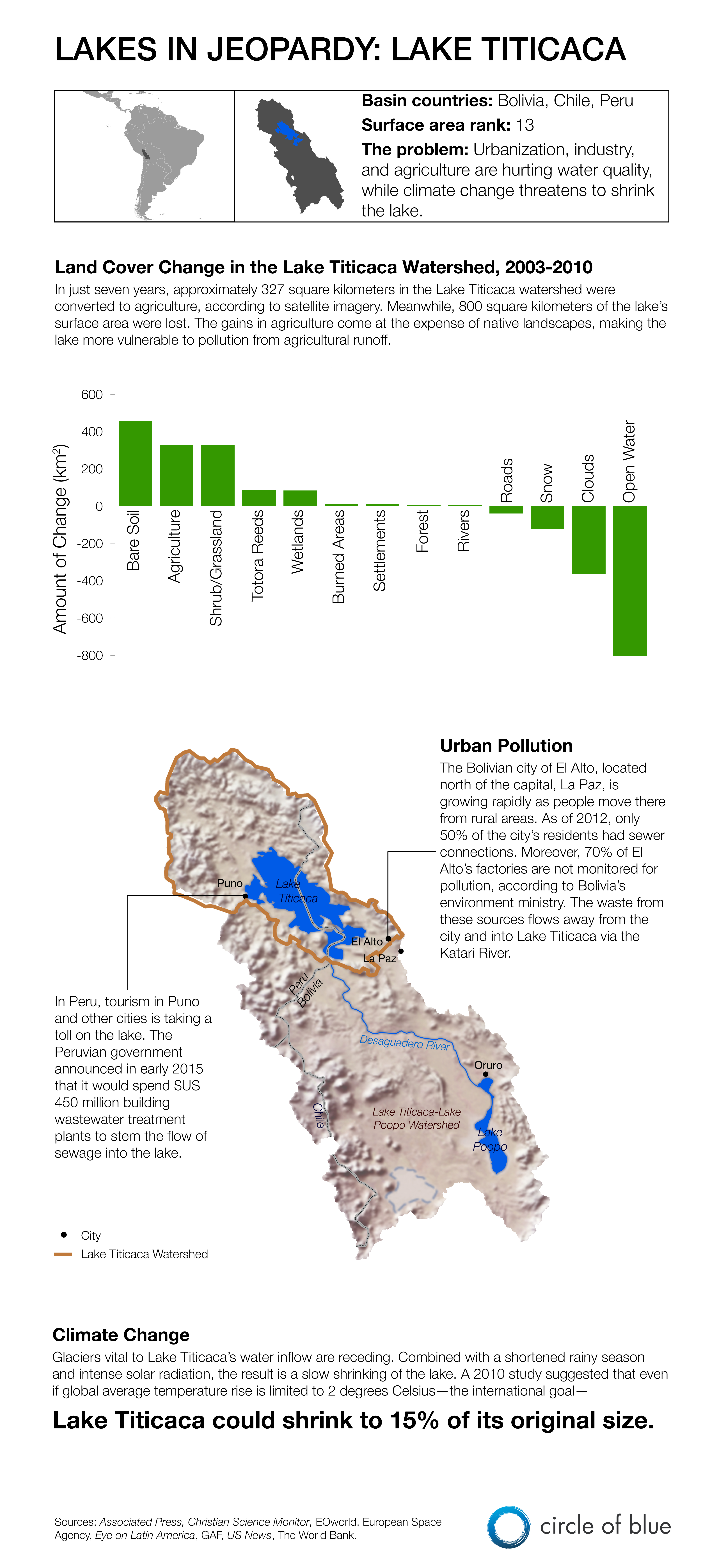
Lake Titicaca, the largest freshwater lake in South America, straddles the border between Bolivia and Peru. Resting more than 3,800 meters (12,400 feet) above sea level in the Andes, it is also known as the highest navigable lake in the world.
The lake, however, is far from remote. More than 1 million people live in the Bolivian cities of El Alto and La Paz, located about 50 kilometers (31 miles) southeast of Titicaca, and pollution from urban and agricultural development is a persistent problem in the lake. At the same time, climate change threatens to melt the glaciers that provide much of the lake’s water.
In the graphic below, the bar chart shows land changes within the watershed between 2003-2010; at the end of that seven-year period, there was more bare soil, agriculture, and grasslands and much less open water. Meanwhile, the map shows
This is the final graphic in a five-week series documenting threats to the world’s largest lakes. The first graphic detailed declining water levels in Lake Urmia, the second explained pollution in Lake Baikal, the third described hydropower and agricultural development near Lake Turkana, and the fourth showed how climate change and invasive species are affecting Lake Superior. Click here to read Circle of Blue’s report about endangered lakes and here to view an interactive map of threats to the 20 largest lakes in the world.
Click here for more information on the World Bank-European Space Agency partnership which made satellite analysis of land cover in the Lake Titicaca basin possible.
Crystal Edmunds and Codi Kozacek contributed to this infographic. Reach Crystal Edmunds at ce301005@ohio.edu and contact Codi Yeager; or tweet to @ce301005 and @CodiKozacek.
is both a scientist and a journalist, she holds an MS in Environmental Engineering from Michigan Technological University, and she brings proficiency in ESRI’s ArcGIS mapping software.




Leave a Reply
Want to join the discussion?Feel free to contribute!