
Too much demand to meet supply.

By Brett Walton
Circle of Blue
The worst drought in the 105-year historical record of the Colorado River has opened a new era of water scarcity that is prompting state and federal water managers to evaluate never before considered options for increasing water supply and reducing demand.
The new ideas for managing the seven-state river basin, which supplies water to 30 million residents and thousands of farms, have attracted increasing attention from agricultural users and other big water interests, particularly in the upper basin states that counted on receiving more water under the region’s near-century-old water use agreement.
In Las Vegas last month, at the annual meeting of the Colorado River Water Users Association—the only organization bringing together stakeholders from each of the seven basin states—opponents and supporters made their views known during a speech by Doug Kenney, the director of the Western Water Policy Program at the University of Colorado-Boulder.
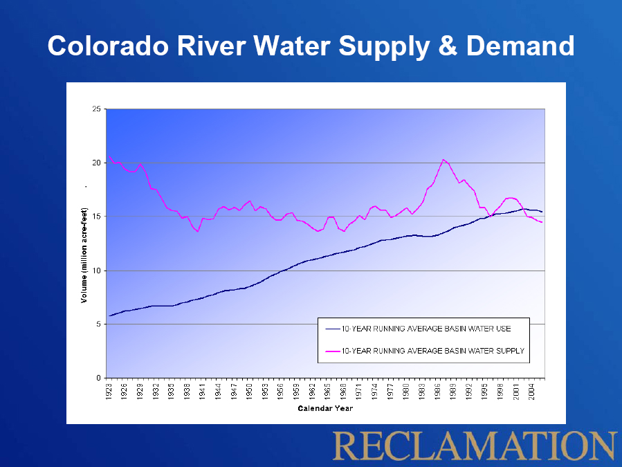
Kenney was invited to Caesar’s Palace to share the first-year findings from his study on water governance in the Colorado River Basin. His message: in a new era of water scarcity along the river—where supply and demand lines have already crossed—traditional water management practices will need to be fundamentally changed.
New options for managing the Colorado include establishing provisions for year-to-year agreements with states and farmers to avoid shortages. They also include improvements in the efficiency of river operations, or by river augmentation, which means adding new supplies from a slew of sources—some viable, some expensive, and some fanciful: desalination, river diversions, and weather modification, respectively.
— Doug Kenney,
Western Water Policy Program
University of Colorado-Boulder
Kenney’s governance study is just one of several such assessments—carried out by academics and federal agencies, as well as state and regional water management authorities—suggesting the need for new ways to manage water flows. The studies are providing a new legal and scientific foundation for defining existing water rights within states, clarifying laws and regulations about how shortages on the river would be handled, and evaluating options for increasing the basin’s water supply and reducing demand.
Kenney argued that the states of the upper basin—Colorado, New Mexico, Utah and Wyoming—are the most vulnerable if future flows are as low as predicted because the river’s legal structure gives priority to Mexico and the lower basin states of Arizona, California and Nevada.
“I thought it was time for someone to stand up at that meeting and start talking about the reality,” Kenney told Circle of Blue. “That there’s just not any water left on that river.”
While there were no catcalls or rotten fruit, Kenney admits that some representatives from the upper basin states were not pleased to hear that water promised to them nearly a century ago under the Colorado River Compact would probably not be available in the coming decades.
Within the basin, the Colorado River supplies water to Las Vegas, Phoenix, and Tucson. Additionally, the river’s water is transferred out of the basin to Albuquerque, Denver, Los Angeles, Salt Lake City, San Diego, and Santa Fe. The Colorado River irrigates four million acres that produce 15 percent of the nation’s crops. The eight major hydroelectric dams along the river have an installed capacity of 4,200 megawatts, which is enough to power more than three million households.
The Problem
Kenney’s assessment comes at an uncertain moment in the long history of managing the West’s most important source of water. On the one hand, the supply of moisture is temporarily abundant. The series of winter storms that hit the nation over last month’s holiday season brought an unexpected bonus to river watchers in the southwest.
Snowpack in the Rockies—which provide 90 percent of the river’s flow—is 35 percent above average, as of January 18. The U.S. Bureau of Reclamation projects that water flows into Lake Powell will be eight percent above average for 2011, making it likely that an extra 3.1 million acre-feet (MAF) of water will be released to Lake Mead from Lake Powell.
One acre-foot is 325,851 gallons, and an additional 3.1 million acre-feet could raise the level of Lake Mead by roughly 30 feet—enough to delay the threat of a shortage declaration in the lower basin for several years. Just a month ago, Arizona officials were scrambling to sign deals to keep Lake Mead’s elevation above the shortage trigger point of 1,075 feet. By the end of last summer, many authorities had predicted that the powerful water-powered electric turbines in Hoover Dam could soon be shut down.
Today, such shotgun agreements might not be necessary, giving state authorities time to work out a more robust strategy.
But scientists studying trend lines and projecting decades into the future are less optimistic because climate change is steadily reducing rainfall and snowpack. “It’s really a crapshoot to predict how river flow will change,” said Richard Seager, a research scientist at Columbia University’s Lamont-Doherty Earth Observatory, who studies the Colorado River. “All we can really say is that the whole area of the basin is in a region that models predict will get drier.”
Compact Complications
The question of river flow, past and future, is a fundamental problem with the Colorado River Compact, the foundational legal document governing the river. Signed in 1922, the compact split the basin into upper and lower divisions and promised each 7.5 million acre-feet (MAF) per year, with the lower basin’s share deliverable as a ten-year average due to river variability. At the time, flows were assumed to be more than 20 MAF per year, but the 16 years of record-keeping prior to the agreement happened to coincide with a period of unusually high runoff.
In the decades since, a longer record has shown that these original calculations were too high. The average annual flow over the period from 1906 to 2007 was 16.4 MAF.
Furthermore, Connie Woodhouse, a geographer at the University of Arizona who works with tree ring data that can be used to estimate precipitation, says the average flow since the 8th century has been roughly 14.7 MAF per year.
— Professor Robert Glennon,
University of Arizona Law School
Including the 1.5 MAF per year guaranteed to Mexico as part of a 1944 treaty, the math in the basin just does not add up, anymore. Measured as a 10-year average, water use exceeded supply beginning in 2003.
If an upper basin state wanted to challenge the legal basis of the allocations, Robert Glennon, a professor at the University of Arizona Law School, told Circle of Blue that the principle of mutual mistake could apply.
“If the parties entered into an agreement with a fundamental misunderstanding of what was going on, the contract may be void,” Glennon explained. “And that surely is the case with the prevailing belief about river flows when the compact was signed.”
Climate Effects
The other wrench in the mix is climate change, though its effect on the laws governing the river is far from clear.
For example, not everyone agrees with Doug Kenney’s assumption that the upper basin is going to be most affected by climate change. It all depends on how the compact is interpreted, argues Dick Wolfe, Colorado’s state engineer, a position responsible for managing the state’s water.
“The question is,” Wolfe told Circle of Blue, “do the upper basin states bear the brunt of climate change alone, or do we share it proportionally [with the lower basin]?”
The key sentence in the compact reads, “The States of the Upper Division will not cause the flow of the river at Lee Ferry to be depleted below an aggregate of 75,000,000 acre-feet for any period of ten consecutive years.” The implication is that withdrawals by the upper basin states will not be so large as to take away water entitled to the lower basin. But how will climate change be considered? In this case, the upper basin states would not be the cause of depletion.
“They have a strong argument,” Glennon said. “But no one [in the basin] wants to go there. That’s why the agreement in 2007 was so important.”
Law and Politics
The 2007 agreement established when to declare a shortage in the lower basin and how to distribute the rationing. Though nudged by the Secretary of the Interior, who acts as water master for the lower basin, the agreement was negotiated between the states themselves. And that’s how the states would like to settle all matters.
If there’s one thing that unifies the Colorado River Basin, it is the opposition to decisions imposed by outsiders and the belief in the value of maintaining the compact, if for no other reason than avoiding a legal war. They do not want intervention by the courts or by the federal government.
During the 2008 presidential campaign, Senator John McCain, representing the lower basin state of Arizona, told the Pueblo (Colorado) Chieftain newspaper that the states themselves should renegotiate the compact. The backlash against McCain came so furiously from parties in the upper basin that he later retracted the statement.
Because of the desire for internal contractual solutions, every basin state is planning, studying, discussing, or negotiating some aspect of how to deal with a water shortage, should one arise. These processes involve water rights, water transfers, reservoir operations, and groundwater management.
— John Shields,
Wyoming Streams Engineer
The study everyone is waiting for is the Colorado River Basin Water Supply and Demand Study, due to be released in January 2012. This joint program between the Bureau of Reclamation, the seven basin states, and a collection of interested parties will assess different supply and demand scenarios through 2060 and consider options and strategies to close any gaps. Interim reports will be made publicly available throughout the year, starting next month with the assessment of supply and demand.
“I think if we do it right,” said co-chair Bill Rinne, the director of surface water resources for the Southern Nevada Water Authority, “this study should be credible in terms of, for the first time, bringing in what different states have used for planning for supply and demand and getting all that in one spot.”
The Plan
One recommendation expected to be included in the final report is river augmentation, increasing the supply in the basin by bringing in water from new sources. “The expectation of most folks involved in the basin is that the study is going to come out supporting augmentation, and it’s going to be able to demonstrate, with data, that the need exists,” said John Shields, Wyoming’s interstate streams engineer and a member of the Colorado River Water Users Association resolutions committee. The CRWUA membership passed a resolution in 2007 advocating that one million acre-feet of new water be brought into the basin by 2050.
“I think, at this time, there is the political resolve and the hydrological necessity to actually see what we can do about increasing the size of the pie, if you will,” Shields told Circle of Blue.
The Southern Nevada Water Authority, which supplies water to Las Vegas, commissioned its own augmentation study in 2007. The most common suggestion was desalination—either by building plants on the Californian or Mexican coast, or by firing up the on-again, off-again Yuma facility near the Arizona-Mexico border. Those plants would allow coastal cities like Los Angeles and San Diego to use more desalinated water, freeing Colorado River water for inland users.
But Robert Glennon, the Arizona law professor, said that augmentation as a solution is “bogus.”
“People talk that game,” Glennon told Circle of Blue. “That’s the historic Western water game. But from where? You can have some desalination, but it’s expensive, uses gads of energy, and you have to get rid of the brine stream.”
Another proposal is to cut the amount of water flowing to farms. “Conservation and efficiency are important, but it’s important to realize that in the face of climate change and drought, they make almost no contribution to the Colorado River,” said Jim Lochhead, the manager of Denver Water, the city’s public utility. “We need a large reduction in demand—namely agriculture.”
Like many cities in the basin, Denver—which gets half its water from the Colorado River watershed—has junior water rights, meaning that it is first to be cut off when water is short, according to the prior appropriation system used by most western states.
Lochhead told Circle of Blue that the state needs to develop a mechanism to have agricultural transfers without rate shocks to urban customers and employment shocks to rural communities, but that discussion has only just started.
For a model, the state can look downstream. California has a successful land-fallowing program between the Metropolitan Water District and the Palo Verde Irrigation District. In dry years, the MWD, which serves 19 million urban residents in southern California, can purchase water from Palo Verde farmers who agree not to plant crops on a corresponding amount of land.
Most states are talking about land-fallowing and dry-year contracts with farmers. The one exception, however, is Nevada. Because the state’s 300,000-acre-foot allocation goes almost entirely to municipal and industrial use, it does not have an agricultural buffer to draw upon, and the legal strictures of the compact make interstate water trades exceedingly difficult.
— Dean David Getches,
University of Colorado Law School
That explains why the Southern Nevada Water Authority is pushing for a 300-mile pipeline to tap a groundwater basin in northeast Nevada and has even floated the idea of a pipeline to the Mississippi, if only to get people talking.
The states of the Colorado River Basin are certainly doing that. There are no options on the table yet, because the table is still being built. The Bureau of Reclamation study is a good point to start from, especially since past discussions about water use have been a little “parochial,” according to UC-Boulder’s Doug Kenney, and “piecemeal,” according to Denver Water’s Jim Lochhead.
“We need to think of some way to get by with less,” David Getches, the dean of the University of Colorado Law School, told Circle of Blue. “We’ve got to find either a re-allocation scheme or a way for everybody within their allocations to have a cushion to adapt to the cycles of drought that we know exist, plus the wildcard of climate change.”
Brett Walton is a Seattle-based reporter for Circle of Blue. Contact Brett Walton
